Joshua Tree National Park - Artist in Residence Day 20

Desert Queen, Eagle Cliffs, Astro Domes, and Bouldering
This was one incredible day. I can't believe how much exploration and adventure can fit into 10 hours. I started the day with a hike in the Queen Valley area, first to Desert Queen Mine, which I've been to several times, and then continuing along to the trail's end at the Eagle Cliffs. After spending another day hiking a popular area that has historical artifacts around, I'll add another quick reminder to hike responsibly, take only photos, leave only footprints, and please stay on trails. This park had nearly 3 million visitors last year, so think of the impact people can have. If just 1 in 100 picks a flower or moves an artifact (yes, this includes old wire and tin cans), that's 30,000 people, and it would be a significant, and sad, impact. So please, be cool.
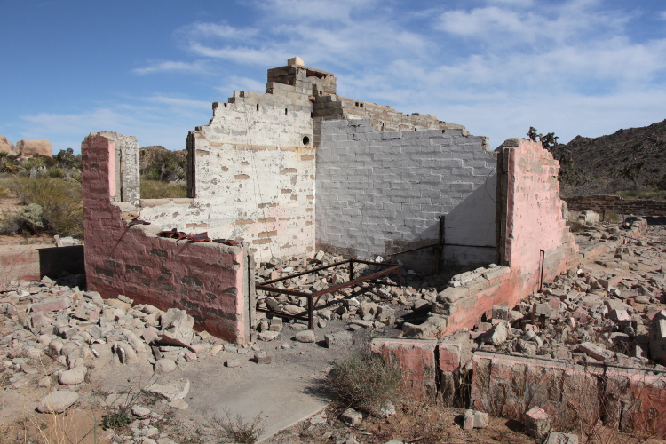
Next I drove over closer to the Barker Dam area to hike out to the Astro Domes, a popular climbing area. The trail leaves from the wash behind the ruins of a ranch house and meanders along the wash for a mile or so. The Astro Domes rise something like 300 feet above the wash, some really impressive boulders. On my way out, I was again thwarted by social trails, and ended up in a different wash, which I didn't realize until I ran across a dam that was different than the one I passed heading in. Just below the dam the wash was choked off by shrubs. I always travel with proper map and compass, and also have some tools on my phone that work off-line. Combining these three, it was easy to backtrack and get on the correct trail.
To finish the day, I met up with a park ranger to do some bouldering. Since the quantity of photos is already ridiculous, I'll create a separate post about bouldering.
 |
| Ruins a short ways down the trail to the Desert Queen Mine. |

 |
| Following the old road down to the wash. |
 |
| View of much of the DQ operations area. The tailings piles help to spot the mine openings. |

 |
| One of the mine shafts the trail passes. The shaft is blocked off further down, you just can't see it in the dim light. |
 |
| The trail passes multiple mine openings, all of which are covered. |
 |
| An enormous grate blocks off a vertical shaft. On one of my previous visits I came across a couple sitting on the middle of this grate, with their kids running around. That's a lot more guts than I have, trusting it to hold weight. |
 |
| A view down the vertical shaft below the grate in the previous photo. |
 |
| Another mine, this one has cool, nice smelling air drifting out. |
 |
| Looking back on the area before the trail turns. |
 |
| There are a number of other mine shafts around, this is by no means an inclusive documentation. |
 |
| Mojave Astor, I think. One fresh bloom, several from last season. |
 |
| The landforms change as the trail gains elevation, larger boulder mounds. |
 |
| A nice view of the trail continuing up the next ridge. |
 |
| More interesting formations. |
 |
| Turned a corner in the trail and suddenly there was this mine. It's blocked off, but down a ways. Yet another reason to stay on trails, it would be easy to get hurt here in a fall, and there is no cell coverage for help. |
 |
| Pinyon pine. |
 |
| The trail passed through an area of large, gnarly dead pine. |
 |
| One of the views. |
 |
| A lizard. I should note that I use a telephoto lens to photograph wildlife. |
 |
| Pancake pear cactus. |

 |
| Leaky tree: I huge pile of hardened sap that dripped on this rock. |
 |
| And another mine shaft right next to the trail, this one almost covered in shrubs as you approach. |
 |
| Another lovely view. |
 |
| More pancake pear cactus |
 |
| Desert mallow. |
 |
| Following the trail back. |
 |
| Cairns are stacks of rocks placed to mark a trail or place of significance. They look neat and can be fun to build, but they do not belong in national parks, staff remove them. Please, don't contribute to cairns, you're just making work for our already too-busy park rangers. |
 |
| Love these large dikes running through the rocks. |
 |
| Back to the mines at Desert Queen. |
 |
| Pano of the area. |
 |
| Some equipment along the trail. |
 |
| Down in the wash are a couple of huge boulders. |
 |
| Looking the other direction. |
 |
| Approaching the boulders, I saw that one has a name and date etched in it. |
 |
| A look back on the Desert Queen Mine. |
 |
| Following the old road up and out of the wash. |
 |
| Driving over to the trail for Astro Domes I took one of my favorite roads to drive, the Queen Valley. |
 |
| An abundance of small flowers. |
 |
| This made me chuckle. I've seen plenty of bikers in the park, but none seem the sort to use their bike as a means of transportation to a trailhead. I hope some do. |
 |
| Caught this guy mid-pushup. |
 |
| I love rock formations. |
 |
| A small dam structure. |
 |
| Following the wash through some fascinating rock structures. |

 |
| The wash opens up for a while. |
 |
| There are so many pancake pear cactus along this route. |
 |
| The top of one of the Astro Domes is visible toward the left. |

 |
| Can't see the bottom half of this Astro Dome, but there's a climber here. |
 |
| Better view of the Astro Domes. |


 |
| More pancake pear as I meander my way back. |


|
| If I were to name this rock in the middle, it would be called Shark Attack. Though I guess there's no fin. So fish attack? |


 |
| Another dam. |
 |
| Choked off wash. |
 |
| There is abundant evidence across the park of previous human presence. If you find such sites, do not disturb them. Here there is a bedrock mortar, used for grinding up foods like acorns by Native Americans. There's also a cold storage compartment built by pioneers. |
 |
| Mojave mound cactus. |
 |
| Wonderland Ranch. |


 |
| Following the trail back to my car. |
Comments
Post a Comment